Disclaimer: Although you may find some practical information about the route in it, this story is principally intended for a creative travelogue, and not a reliable route description. One attempting to climb Mount Halgurd independently must recognize that it entails dangers transcending all levels of hiking experience.
Planning a trekking trip in Iraq
Why do you travel?
To take a break from routine? Take selfies in front of landmarks you’ve seen a million times before on screens? Meet new people and cultures? Solve your prejudices and learn things about the world? Perhaps to withdraw from civilization, experience nature in its wild, raw form and meditate on your place within it?
I suppose we all travel for complex combinations of the above and countless other reasons. My case gravitates towards the last example.
In other words, what is the first search you run ahead of visiting a new place?
“Country x… things to see, accommodation, food, travel guide?”
For me, this almost invariably is “country x mountains”.
So, shortly before crossing the border from Turkey in autumn 2021, I searched for “Iraq mountains”.
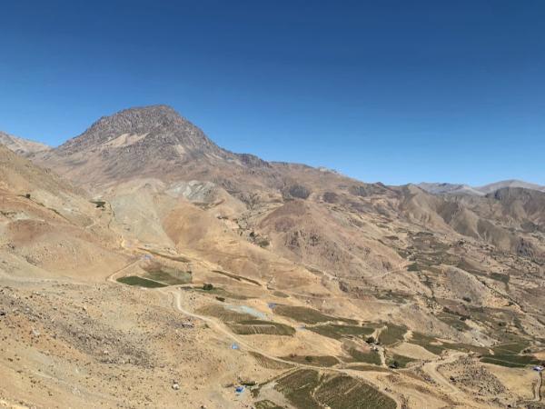
The first SERP came dominated by posts about a mountain called Halgurd. This turned out to be the highest summit of the Zagros Range situated entirely within Iraq.
Its 3607-meters elevation and its snow-carpeted pictures took me by surprise. I bore in mind the stereotypical image of Iraq as a desert plain—date palms and broken tanks scattered throughout. I knew that the country’s Kurdish-controlled northern extremity is mountainous. But my intuition had underestimated the scale of those geographical features.
This mountain could be justly described as enormous. It imposingly soared and overlooked the cragged, surrounding desolation from far above. Its sheer grandeur called one’s heights-chasing spirit. And it appeared to be the sole mountain in the region that’s being climbed relatively regularly.
The technical title of Iraq’s highest point belongs to another mountain called Cheeka Dar, which is four meters taller than Halgurd and lies a few miles northeast of it on the Iranian border. This latter piece of information means that the mountain is monitored by the theocracy’s military, who aren’t as a rule delighted by infidels backpacking beside their positions. I couldn’t spot any recent account from someone who trekked it.
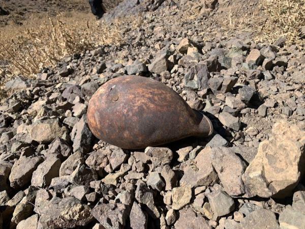
Halgurd’s depiction was unnerving enough in the handful of stories at hand. PKK fighters shelter in the area and clash with the local Peshmerga while occasionally being bombed by the Turkish and Iranian air forces. To not go into political details here, let it suffice that bullets are fired and explosives are blown. To top that off, minefields from the 1980s Iraq-Iran War remain uncharted on the mountain’s periphery.
Most of the relevant content—directly or indirectly—originated from a bunch of local mountain guides. This was bad for two reasons: first, because they give too little practical information regarding the route; and second, because it’s difficult to judge to what a degree they overdramatize the aforementioned perils.
Of course, it is straightforward to hire one of them and just do the tour the easy way. Don’t misunderstand me, I’m sure they’re good professionals and may charge reasonable rates. But my idea always is to travel independently as long as possible by any means.
So we made a plan—which was to reach the village of Choman at the mountain’s foot, gather information on the spot, and accordingly plan further—and proceeded with its execution…
This story is an excerpt from my book "Backpacking Iraq", wherein I recount my journey through this misunderstood and fascinating country. The entire book is available to read online for free. But if you'd like to get it on your e-reader or as physical copy (and, doing so, support my creative activity), you may check it out on Amazon.
From Erbil to Choman
It was early but hot already when we left our friend’s place in Erbil’s suburbs and stopped the first passing-by cab. The driver knew decent English and right away understood my request to be brought wherever we could catch a bus to our destination. And to my gratitude, he proved zealous to assist us further.
He connected us with a friend of his in Choman, who arguably was the go-to man when information about the mountain is sought; we spoke on the phone and agreed to call him as soon as we arrive in the village. Reaching the station, he figured out on our account that no buses go to Choman and instead dropped us off beside a shared taxi about to head that way. Before leaving, he gave us his number, in case we need anything, and even invited us to stay in his house after we return.
We were the first two passengers. Two more were pending to fill the car and start. It shouldn’t take long. We put our luggage in the boot and waited… for hours. We had breakfast; read; ran into that funny bus driver who had brought us there from Turkey and joked about with him a bit; had lunch; asked the shared taxi driver whether anybody’s coming many a time; and at last, past midday, a young boy and an old man showed up.
The former sat in the front, the latter shared the rear seat with us, and we hit the road. We rapidly left behind Erbil’s plateau to enter a narrow gorge penetrating deep into the mountains. Lofty, jagged peaks and ridges rose on both sides. Speedy, emerald streams gurgled pleasingly on their way down beside the road, vivifying beautiful orchards and scattered small communities.
Unlike the driver and the boy, our aged co-passenger knew English and proved an agreeable company for killing the time with some chat. Except for one quick stop at a fishmonger’s for him to buy some of the river’s lured-to-death creatures, we drove nonstop through the entire afternoon. The ultimate specks of twilight had just faded off the sky when we came to a halt on Choman’s main road.
Looking for information and accommodation in Choman
Our co-travelers set off walking to their homes. The driver waited for us to call our contact, and as requested by him, he drove us a few blocks away to his house’s gate.
I had understood the dude was a mountain guide, and I was prepared for him to pitch his services. But since we were connected by his friend, I expected a somewhat less professional and more affable reception. I assumed he’d recognize that we aren’t the pay-to-follow-along kind of travelers and anyway help us carry out the trek on our own—if not out of pure kindness, after calculating that we can send future business his way in reciprocation. This wasn’t the case, however.
Asking us to leave our luggage outside, he invited us past the threshold of his door. His living room was spacious and frugally yet niftily furnished with an elaborate carpet and a wall-long, elegant couch. Present in the room were his wife, sitting discreetly and utterly silent in a corner, and his little daughter, dashing around the room and proudly exhibiting her various toys and impressive English-language skills.
He had us seated on his ornate, crimson cushions. And without first offering a cup of tea or anything, premeditatedly wearing a branded hiking outfit and an expensive-looking watch, in a business-like manner and tone, he went straight to the point:
“How can I help you?”
To which I replied: “Yeah, you could very much help us by providing some information about the route; and even more if you, by any chance, could let us pitch our tent in your garden for the night.”
He kissed off both parts of my appeal and, instead, went about enumerating and warning against alleged great dangers that this trip entails, as well as apprising me of the army’s unwillingness to let through unescorted hikers. I had to interrupt him before concluding with his offer and clarify that we aren’t at all interested in an organized tour—foremost because we can’t afford it—and that we’re ready to take our chances with the army.
Reluctantly, he then agreed to go over the map with me. While Sophie got busy playing with the little girl, I showed him the draft route I had plotted utilizing satellite imagery. He looked at it startled and asked where I had found it—as if a matter of copyright infringement. Although he knew the landscape by heart, he didn’t prove adept at map-reading. He had a hard time associating his experience with the area’s 2D model.
In the end, I did not retrieve from him any tips of essential value. We only worked out a couple of minor adjustments to my original itinerary. What he was unambiguous about, however, was that on no account should we attempt to reach the summit from the west, instead of the common east approach—for a reason he couldn’t definitively articulate, but I figured out later.
Anyway, it was getting late. We’d need a good rest were we to attempt the mountain tomorrow. The guide didn’t let us camp in his garden, but he directed us to a cheap guesthouse. So we shouldered our backpacks and strode that way.
But upon arriving on the spot, we saw nothing but a forsaken little house. It didn’t seem to accept guests since it lacked a landlord. We later heard that it opens only to house seasonal Iranian workers.
We carried on walking along the main road until we encountered a big motel sign attached to a building; the sole place we saw in the village that explicitly advertized accommodation. It didn’t have such a thing as a reception, but the door to the dimly lit pizzeria on its ground floor was open.
The two idling teenage boys inside didn’t seem as keen as a business-anticipating hotel owner ought to be. Quite the contrary, “no rooms” was the only curt phrase one of them uttered before re-immersing his gaze on his mobile phone. After persisting, I furthermore realized that those two words made up the entirety of his English vocabulary. Finding a bed in this village seemed then a complicated task.
Walking around a bit and failing to find another place, we went back and phoned the guide to facilitate interpretation. It took a few consecutive calls, my mobile repeatedly shifting between my ear and the boy’s, until we accomplished to make some sense of each other. They sort of condescended to grant us a room. It lacked bedsheets, and the running water was more trickling than running, but what we needed—a mattress and pillows—were there. After ordering a pizza that took ten times more time to be prepared than to be eaten, we went to bed.
First attempt to approach Mount Halgurd from the east
The sun was out by the time we woke up, but that wasn’t noticeable in our windowless room. I saw the brilliant blue sky only after I went out for my coffee.
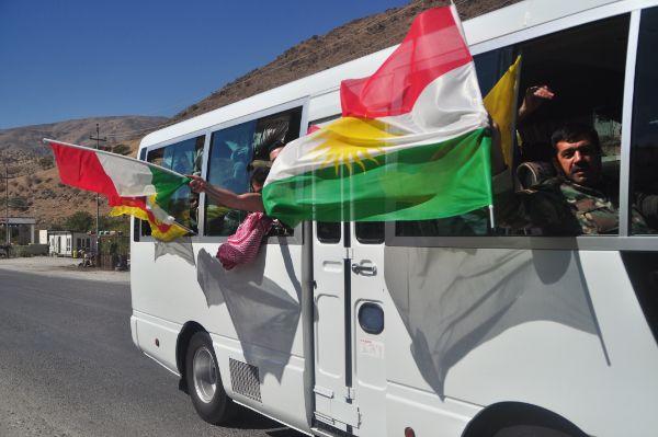
It was the day after the national election, and the village had a jubilant mood. Civilians and servicemen flooded the main road, parading back and forth on foot and wheels, waving flags and honking merry cadences.
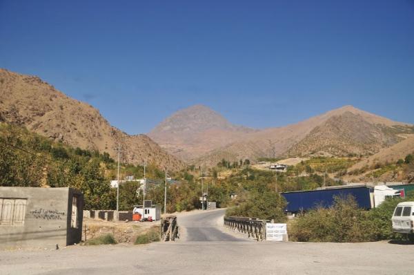
We took our time to buy food provisions from the shop across the street and pack. The heat was harsh when we began ambling eastward out of the village and toward the trailhead. We had a 3-km walk until the point we’d leave the main road, but we saved that.
Still inside the settlement, a driver stopped voluntarily and offered us a ride. He worked as a border guard and was now commuting to his post. He spoke English and was extremely kind, again and again apologizing for not having the time to drive us further up, against our reassurances that he’s already doing us a huge favor.
It didn’t take five minutes up the next road until we got offered a new ride. This time, it was a family from a local hamlet in a pickup truck. They had no free seats, but they prompted us to hop into the trunk. This trip was going smoothly; we were cutting down a whole day of walking. But then, sure enough, the army stopped us…
Trying to get a hiking permit from the Peshmerga
The checkpoint was a single-room concrete structure adjoined by a mound with sandbags and a heavy machine gun. Down by the road, a Kurdish flag and a bench were all the remaining additions to the complex.
The oldest-and-superior-looking of the present guards—who also had the thickest mustache—jumped urgently to halt the car’s advance. He stood by the window and exchanged a brief dialogue with the driver, of which I made out only our destination’s name.
Then he stepped aside and had a peek in the trunk, upon which moment his face took on an expression that, was it expressed by his tongue, would come like “what the fuck!”. And before ordering us to get out together with our bags, he turned to the driver and said something Kurdish that must have meant something like “who the fuck are they?”.
The car drove its way, and a few calls later, he passed me the phone. The voice explained in English that we need permission to be let past and somebody will come to drive us to where we could get that. Waiting, we sat with the soldiers on the bench, in the shade of a lone tree, and took selfies while attempting to communicate with gestures.
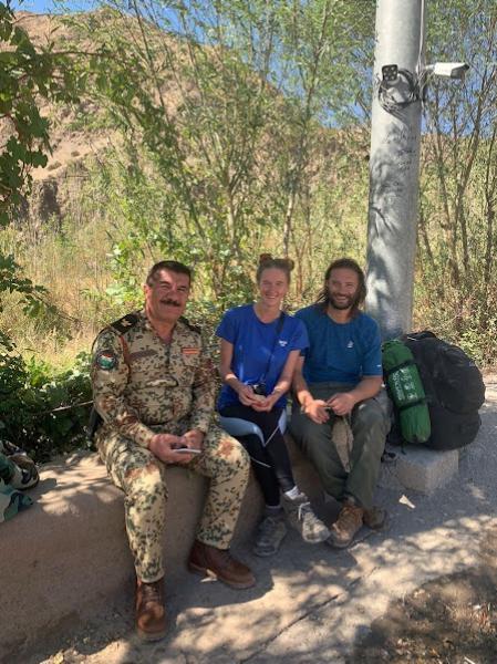
The car came and drove us back to Choman and into Peshmerga’s headquarters. About an hour of sitting later, we were called into a room. It was difficult to communicate with the officer behind the heavy desk. Verbal means were altogether excluded. The fact that even Google Translate didn’t include his language amplified the difficulty.
The room got crowded as more and more staff came and collectively tried to make sense of what we want. Eventually, after many cups of chai, they delivered the sad and plain news that they cannot give us permission.
The room got vacated, and we stayed alone with the original man. Over the next few minutes, giving a laudable pantomime performance, he effectively explained to us that:
“Look. In case you get caught, I know nothing. But were you to wait for dark and go up the west side,”—the one the guide discouraged us from taking (hence the reason)—“no-one will stop you.”
Well, that was our only reasonable option for climbing that mountain.
First day climbing from the west
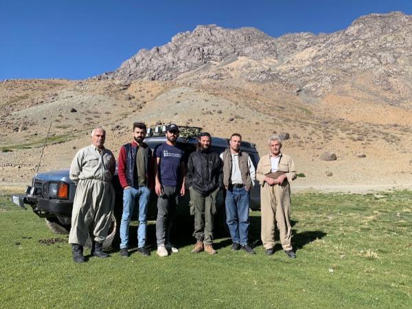
We still had plenty of hours till dusk. So we settled in a lovely restaurant in the village center. The food was delicious and generous. The owner, staff, and the present customers were a pure joy to interact with.
One of them, Umed, a very smart and polite guy, spoke good English. Besides his excellent company, he offered us a ride to his village, called Delza, a good three steep miles along our way.
As we drove the narrow, twisting road up the slope, the sun was about to plunge behind the ridge. The valley below was relishing the last moments of golden light. The sunrays had retreated high in the sky when we stopped at his uncle’s house, overlooking an incredible view from inside a lush orchard.
Having filled a bag with plucked apples, grapes, and pomegranates, we drove a little further to a resting structure they had built beside a spring and a trough. Some of Umed’s cousins were there. They had assembled a heap of stones and waited for him to haul them down in his pickup. We chilled a bit while they were at work, thanked, goodbyed, and began trekking.
It was getting dark. We wouldn’t go far. The next water source was in a hamlet called Nelme, a couple of miles up the road. The twilight was receding when we made it there, in a tiny secret valley inhabited by one extended family, their livestock, and shepherd dogs. A few shacks and scant farms were the only manmade features.
We spotted the water in a cistern and camped atop a nearby hillock. By the time we’d cooked and eaten dinner, darkness was absolute. Nothing but a sole lamp down in the settlement, a smoking fire on the massif across the valley, and innumerable stars interrupted it. The quiet was correspondingly profound and the breeze caressingly cool. All was perfect to go to sleep.
From Nelme to the mountain foot
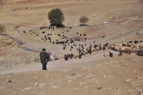
The dogs began barking like mad at the first hint of daybreak, the vilest and loudest one of them right outside of our tent, but we tolerated them and kept on snoozing. What eventually aroused us was the sun rising over the ridge and turning the tent’s interior into something akin to a sauna.
Not a single trace of a cloud was to be seen. The shepherds were up already, leading their animals to scattered patches of pasture. To our relief, the ding of the roaming sheep diverted the dogs’ attention from the novelty of our little encampment. Only one remained lingering close by.
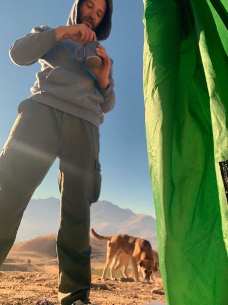
He was young and quiet, the chummiest of the lot. He hadn’t yet grasped the point of chasing around those woolly, imbecile quadrupeds, and found it more amusing to hang out in our company—especially after we began breakfasting on exotic viands that didn’t make a common part of his diet.
Up to then, I hadn’t incorporated in my knowledge trivia the fact that grapes are poisonous to dogs. But Sophie, who is a veterinary nurse by profession, taught me just that; unfortunately, only after we noticed the poor bugger having ripped open and looting our grapes bag. I’m afraid he’d gobbled quite a portion by the time we stopped him. I hope he survived; he still looked perfectly hale until we packed and left. If not… my sincere condolences to the family.
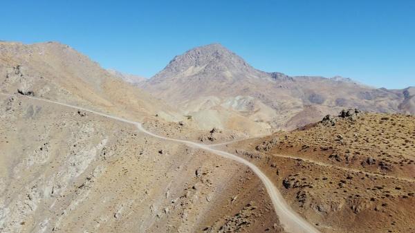
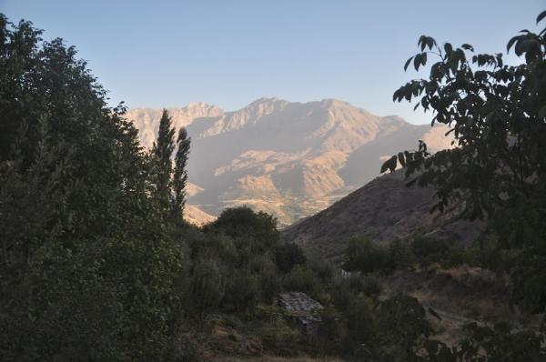
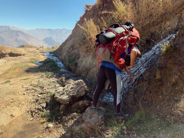
We set off walking along the local dirt road; around an arete, up a pass, and down the next valley. Another rudimentary settlement lay there amid small tomato farms. Then we ascended someway up the next massif and advanced deep north along a smooth path parallel to the slope. The view of the main valley was wide open and impressive at all times. That was also the only part of the route where we picked mobile signal from Choman.
One of my principal worries about this trip—besides bombs and bullets and stuff—was water. Those who’ve hiked in the Middle East know what a rarity this might become in the area. But to my pleasant surprise, from there onwards, bountiful, clear brooks streamed over the path or close beside it all the way to the mountain foot.
Afternoon, some 10 km covered since the morning, we arrived at a broad, lovely meadow and stopped for lunch. That would have been an idyllic camping spot, but we still had daylight and thought it best to get closer to the peak.
While we packed to resume our way, a genial local family drove by in their jeep and stopped to inspect. It amazed them to see us two foreigners up there on our own and seemed proud of the interest we’d taken in their mountain. Wishing us good luck, they drove away. They were the last humans we were to encounter until the day after tomorrow.
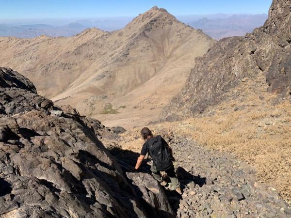
Further, we got into a deep, narrow gorge and followed a faint trail up through it. The track was often buried under landslides, where we had to show extra caution in case they had carried down mines.
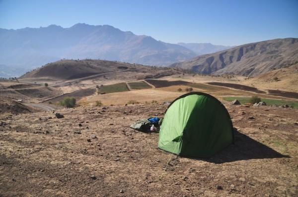
Camping ground wasn’t abundant inside the gorge. It took some 3 km of additional way since our lunch break until we spotted a nice, flat patch of grass. Darkness fell swiftly, and the temperature plummeted in response. We were soon wrapped inside the sleeping bag, resting our fatigued muscles before the alarm’s expected cue in the middle of the night.
To the summit of Mount Halgurd and back down
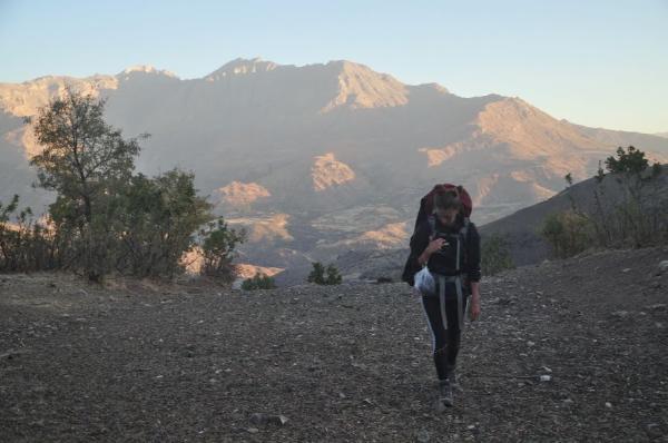
The firmament was pitch-black and saturated with faraway, glowing worlds of the Milky Way when we left the tent and most of our stuff waiting for our return from the mountaintop. Carrying but torches, water, snacks, and valuables, we walked light along a vague path and up to a desolate plateau, where every hint of trail disappeared.
Paths and roads had led us safely up to there. But now, mines could lurk anywhere below our feet. Guided by goat excrements, we carefully trod towards the peak’s looming silhouette. And with all our limbs in place, we entered the narrow gully that would take us to the top.
It was bleak and dreary in there. The only manmade object we saw along the way was a long-rusted military helmet. Not even goats condescended to use this place as a toilet. So there were no clues of safe steps anymore; only hope. However, we rested assured in the assumption that in no reasonable conditions of warfare would an army want to waste their explosive resources on a random cliff 3,000 meters above sea level. And we climbed ahead rather unconcerned.
The ascent itself was steep and involved a little scrambling here and there, but was a piece of cake overall. I cannot compare it to the standard approach from the east—since I never did it—but judging by the map and what I observed down the other side, I believe the route we chose was the easiest possible.
Light inundated the high sky when we were about halfway to the summit. And the sun arched above the ridge only minutes before we reached it. We welcomed its advent with a brief break for rest, breakfast, and removing clothing layers. Soon thereafter, we stood in the position where a signboard and an array of Kurdish flags marked the summit of Mount Halgurd.
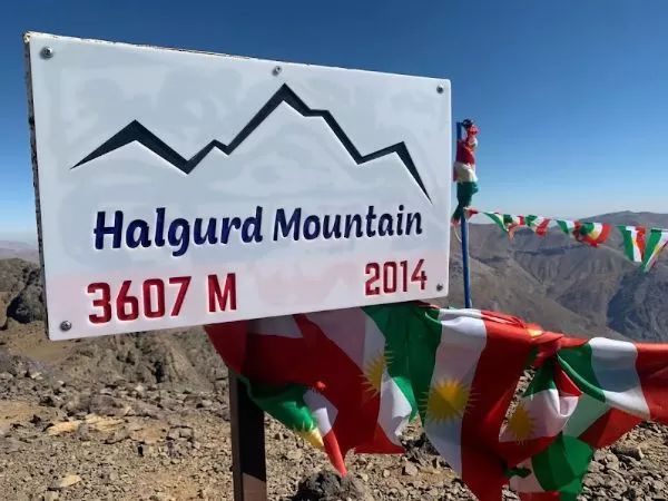
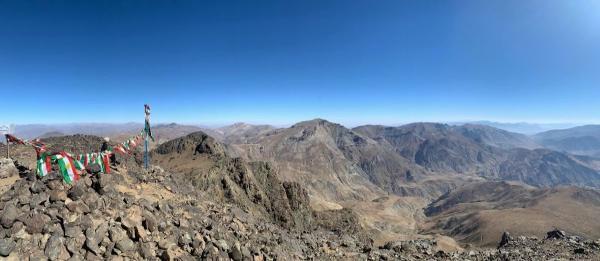
It was warm and bright. Chains of barren mountains extended to every limit of the visible horizon, deep into both the Iraqi and Iranian sides. Cheeka Dar was the only feature within sight that rose above us. Having amply enjoyed the serenity of this splendid view, we began on our long way back.
Hours later, we had collected our stuff from last night’s home and were setting up a new one close to the place we camped on the first night.
Our last morning on this mountain was again sunny and mild. Leisurely—as usual when only a short downslope separates you from much-coveted amenities—we packed and went.
I was betting on high odds of someone giving us a ride after Umed’s village. Indeed, steps past his uncle’s house, another cousin braked beside us and opened his car’s doors.
He dropped us off at the restaurant’s doorstep, wherein we got rewarded with a hearty meal and cordial company. Late afternoon, Umed drove us past a military checkpoint on the outskirts of the village and stopped for us a passing-by car bound for the next town of Soran.
Photo Gallery
View (and if you want use) all my photographs from Mount Halgurd and Choman.